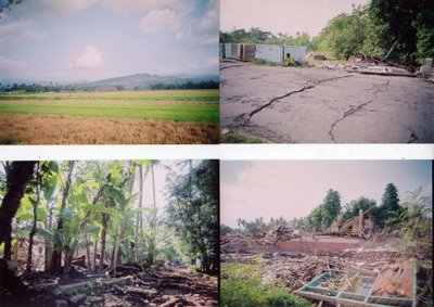
This is the pictures of the landscape. Notes for pictures clockwise:
1. The hills and ricefields. Klaten is a beautiful place with this typical view of hills and green lanscapes. Before the disaster, under the hills you could see many houses, but now there are only ruins.
2. The main road towards the districts of Gantiwarno and Wedi cracks due to the earthquake. The little girl sitting near the wall was a refugee who was on the way back from donation center. She was taking a rest after a long walk with heavy bags filled with foods and fresh water. The ruin next to her was a little house that collapsed during the earthquake.
3. The neighbourhood. This is the picture taken from the front yard of my grandmother's house. Even my motorbike couln't pass on the road. It was full of collapsed brick wall. See also the houses behind the trees. All fell down...
4. This ruin was two elementary schools and a kindergarten. Children couldn't go to school, they don't know until when.
27 May 2006, 05:56 a.m., Western Indonesia Time (GMT+7)
The earthquake in 5.9 Richter scale shocked three provinces in Java: Central Java, Yogyakarta and East Java.
The earthquake already took 5,196 lives, injured nearly 30,000 people and destroyed more than 200,000 houses and public facilities. (www.mediaindonesia-online.com, 29 May 29, 2006)
One of the most severed towns is Klaten, my father’s hometown. It is the 3rd town with most victims (685 died) and 75,000 people lost their homes. Most of the victims of the disaster are now homeless, with minimum health services, minimum food and clothes. The roads to go to disaster area are split by the tectonic cracks. The condition is worsened by the lower popularity, poorer access and less health services compared to the other severed area.

